 Altădată
Lost church · 1720–1724; demolată 1977
Enei Church
Enei Church (originally Ienei) was built in 1720–1724 on the site of a wooden foundation from 1611 and preserved an important ensemble of mural paintings. Damaged by a crane during work at the Dunărea apartment block, which had collapsed in the March 1977 earthquake, it was demolished on 28–30 April 1977, after its removal from the list of historic monuments had been requested. It was the first in a series of 23 Bucharest places of worship torn down under the Ceaușescu regime. The name of Enei Street preserves the memory of the site.
See the place on the old maps ›Text source: ro.wikipedia.org · summary based on the source
Old photographs
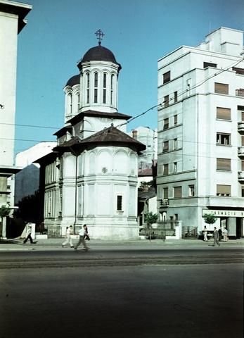
Bulevardul Nicolae Bălcescu, Biserica Enei
1956 · FORTEPAN / Csaba László örökösei · CC BY-SA 3.0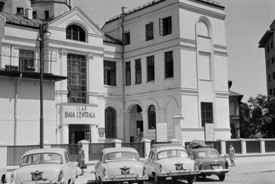
Strada Biserica Enei, Baia Centrală (közfürdő), az 1977-es földrengés után lebontották
1965 · FORTEPAN / Bojár Sándor · CC BY-SA 3.0
On the old maps
The place appears on 45 maps and images, from 1790 to today:
- 1790 · Specht Plan
- 1791 · Ernst Plan
- 1846 · Borroczyn Plan
- 1852 · Borroczyn Plan
- 1864 · Szathmari Plan
- 1871 · Pappasoglu Plan
- 1883 · Cerkez Plan
- 1893 · Orăscu Plan
- 1896 · J. Don Plan
- 1900 · Plan of Bucharest 1900
- 1911 · Army Geographic Institute Plan
- 1914 · Socec Plan
- 1921 · Mihai Pantea Plan
- 1926 · Union Plan
- 1927 · Aerial photo 1927
- 1927 · Socec Plan
- 1928 · Industrial Plan
- 1931 · STB Plan
- 1931 · Unirea Plan
- 1934 · Wahing Plan
- 1938 · Aerial photo 1938
- 1938 · Teodorescu Plan
- 1939 · Simboteanu and Moldoveanu Plan
- ~1940 · Artillery Firing Plans
- 1943 · Aerial photo 1943
- 1962 · Cadastral Plan (center)
- 1966 · Satellite image 1966
- 1968 · Map of Bucharest 1968
- 1969 · Map of Bucharest 1969
- 1972 · Satellite image 1972
- 1974 · Cadastral Plan (center)
- 1976 · Satellite image 1976
- 1977 · Satellite image 1977
- 1978 · Satellite image 1978
- 1979 · Satellite image 1979
- 1980 · Satellite image 1980
- 1982 · Satellite image 1982
- 1982 · ITB Plan
- 1983 · Satellite image 1983
- 1984 · Satellite image 1984
- ~1985 · Soviet Topographic Map
- 1990 · Cadastral Plan
- 2001 · AGC Polonia Plan
- 2017 · Orthophoto 2017
- today · Current satellite
Nearby
- Ion Mincu Institute of Architecture Palace · 70 m
- St. Nicholas Dintr-o Zi Church · 120 m
- University Palace · 140 m
- St. Sava Monastery (lost) · 180 m
- Statue of Ion Heliade-Rădulescu · 180 m
- Statue of Spiru Haret · 210 m