 Altădată
Historic building · 1959–1960
Palace Hall
The Palace Hall (Sala Palatului), behind the Royal Palace, was built between 1959 and 1960 for the 3rd Congress of the ruling party, to a design by the architects Horia Maicu, Tiberiu Ricci and Ignace Șerban. It occupies the site of the royal residence called the “New House” (Casa Nouă), where Marshal Ion Antonescu was arrested on 23 August 1944 and which was destroyed by German bombing the following day. It originally had 3,150 seats; from 1982, on Ceaușescu's orders, its capacity exceeded 4,000. It has hosted international congresses and the “George Enescu” Festival.
See the place on the old maps ›Text source: ro.wikipedia.org · summary based on the source
Old photographs
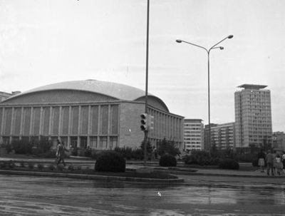
Strada Știrbei Vodă, szemben a Sala Palatului koncertterem
1961 · FORTEPAN / Bán Tamás · CC BY-SA 3.0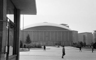
Strada Știrbei Vodă, szemben a Kongresszusi Csarnok (Sala Palatului)
1962 · FORTEPAN / Gazda Anikó · CC BY-SA 3.0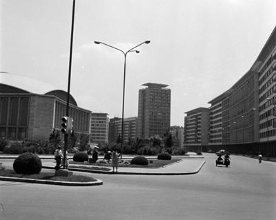
a Strada Ion Câmpineanu (13 Decembrie) blokkházai, balra a Kongresszusi Csarnok (Sala Palatului)
1964 · FORTEPAN / Fortepan/Album018 · CC BY-SA 3.0
Forradalom tér, jobbra a Sala Palatului
1966 · Fortepan / Szánthó Zoltán · CC BY-SA 3.0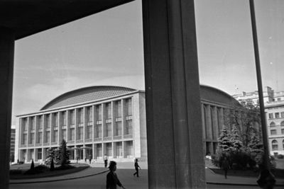
Strada Ion Câmpineanu (13 Decembrie), Kongresszusi Csarnok (Sala Palatului)
1966 · FORTEPAN / Szűcs Lóránd · CC BY-SA 3.0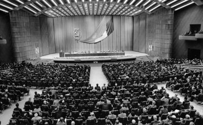
Strada Ion Câmpineanu 28., Kongresszusi Csarnok (Sala Palatului)
1968 · FORTEPAN / Sütő András örökösei · CC BY-SA 3.0

On the old maps
The place appears on 45 maps and images, from 1790 to today:
- 1790 · Specht Plan
- 1791 · Ernst Plan
- 1846 · Borroczyn Plan
- 1852 · Borroczyn Plan
- 1864 · Szathmari Plan
- 1871 · Pappasoglu Plan
- 1883 · Cerkez Plan
- 1893 · Orăscu Plan
- 1896 · J. Don Plan
- 1900 · Plan of Bucharest 1900
- 1911 · Army Geographic Institute Plan
- 1914 · Socec Plan
- 1921 · Mihai Pantea Plan
- 1926 · Union Plan
- 1927 · Aerial photo 1927
- 1927 · Socec Plan
- 1928 · Industrial Plan
- 1931 · STB Plan
- 1931 · Unirea Plan
- 1934 · Wahing Plan
- 1938 · Aerial photo 1938
- 1938 · Teodorescu Plan
- 1939 · Simboteanu and Moldoveanu Plan
- ~1940 · Artillery Firing Plans
- 1943 · Aerial photo 1943
- 1962 · Cadastral Plan (center)
- 1966 · Satellite image 1966
- 1968 · Map of Bucharest 1968
- 1969 · Map of Bucharest 1969
- 1972 · Satellite image 1972
- 1974 · Cadastral Plan (center)
- 1976 · Satellite image 1976
- 1977 · Satellite image 1977
- 1978 · Satellite image 1978
- 1979 · Satellite image 1979
- 1980 · Satellite image 1980
- 1982 · Satellite image 1982
- 1982 · ITB Plan
- 1983 · Satellite image 1983
- 1984 · Satellite image 1984
- ~1985 · Soviet Topographic Map
- 1990 · Cadastral Plan
- 2001 · AGC Polonia Plan
- 2017 · Orthophoto 2017
- today · Current satellite
Nearby
- Stejarul Church · 80 m
- Brezoianu Church (lost) · 120 m
- St. Ionică Church (lost) · 140 m
- Reformed (Calvinist) Church · 150 m
- Kretzulescu Church · 160 m
- Lutheran Church (old church) · 210 m