 Altădată
Existing church · 1778; înlocuită 1851–1853
Lutheran Church (old church)
Bucharest's Lutheran community, made up mostly of Transylvanian Saxons, received in 1753, through the intervention of the Swedish ambassador to the Porte, a charter from Prince Constantin Racoviță allowing it to build a wooden church. The church, consecrated on 15 August 1778 and known as the “Lutheran Church of St. Mary”, became too small as the community grew in the 19th century. Between 1851 and 1853 the present Evangelical church on Luterană Street was built to plans by the architect A. Mohnbach; at 36 m tall, it was then the tallest building in the city.
See the place on the old maps ›Text source: ro.wikipedia.org · summary based on the source
Old photographs
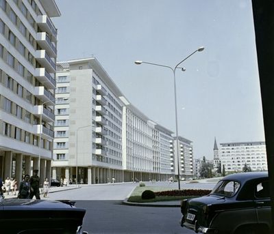
a Strada Ion Câmpineanu (13 Decembrie) blokkházai, háttérben a Strada Luterană torkolata és az evangélikus tem
1964 · FORTEPAN / Fortepan/Album018 · CC BY-SA 3.0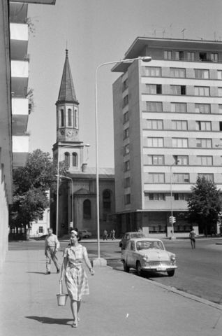
Strada Ion Câmpineanu a Strada Luterană felé nézve, háttérben az evangélikus templom
1965 · FORTEPAN / Bojár Sándor · CC BY-SA 3.0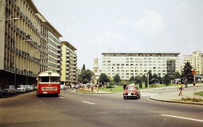
a Strada Ion Câmpineanu (13 Decembrie) blokkházai, háttérben a Strada Luterană torkolata és az evangélikus tem
1967 · FORTEPAN / Darányi Sándor · CC BY-SA 3.0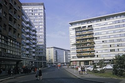
Strada Ion Câmpineanu (13 Decembrie), szemben a Strada Luterană torkolata
1970 · FORTEPAN / UWM Libraries · CC BY-SA 3.0
On the old maps
The place appears on 44 maps and images, from 1790 to today:
- 1790 · Specht Plan
- 1791 · Ernst Plan
- 1846 · Borroczyn Plan
- 1852 · Borroczyn Plan
- 1864 · Szathmari Plan
- 1871 · Pappasoglu Plan
- 1883 · Cerkez Plan
- 1893 · Orăscu Plan
- 1896 · J. Don Plan
- 1900 · Plan of Bucharest 1900
- 1911 · Army Geographic Institute Plan
- 1914 · Socec Plan
- 1921 · Mihai Pantea Plan
- 1926 · Union Plan
- 1927 · Aerial photo 1927
- 1927 · Socec Plan
- 1928 · Industrial Plan
- 1931 · STB Plan
- 1931 · Unirea Plan
- 1934 · Wahing Plan
- 1938 · Aerial photo 1938
- 1938 · Teodorescu Plan
- 1939 · Simboteanu and Moldoveanu Plan
- ~1940 · Artillery Firing Plans
- 1943 · Aerial photo 1943
- 1966 · Satellite image 1966
- 1968 · Map of Bucharest 1968
- 1969 · Map of Bucharest 1969
- 1972 · Satellite image 1972
- 1974 · Cadastral Plan (center)
- 1976 · Satellite image 1976
- 1977 · Satellite image 1977
- 1978 · Satellite image 1978
- 1979 · Satellite image 1979
- 1980 · Satellite image 1980
- 1982 · Satellite image 1982
- 1982 · ITB Plan
- 1983 · Satellite image 1983
- 1984 · Satellite image 1984
- ~1985 · Soviet Topographic Map
- 1990 · Cadastral Plan
- 2001 · AGC Polonia Plan
- 2017 · Orthophoto 2017
- today · Current satellite
Nearby
- Reformed (Calvinist) Church · 60 m
- Stejarul Church · 170 m
- Palace Hall · 210 m
- White Church · 220 m
- Episcopiei Church (metochion of the Bishopric of Râmnic) · 250 m
- St. Joseph Cathedral · 260 m