 Altădată
Historic building · 1868
Capșa House
On the site of the houses of the boyar Radu Slătineanu, the Italian Momolo, former cook of Prince Grigore IV Ghica, opened a renowned eatery in 1830, with a ballroom above it. In 1868 the building was bought by the brothers Constantin and Grigore Capșa, who opened a confectioner's shop here; Grigore added a hotel in 1886 and the café in 1891. Casa Capșa became a purveyor to the Court in 1869 and was for a long time the meeting place of high society, politicians and journalists, while the café remained linked to Bucharest's bohemian life. It was nationalized in 1948.
See the place on the old maps ›Text source: ro.wikipedia.org · summary based on the source
Old photographs

Casa capsa
1900 · Public domain
Angriff vom 15. April 1944, Restaurant Capsa, nahe
1944 · Willy Pragher · CC BY 4.0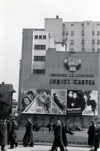
Calea Victoriei, balra a Strada Edgar Quinet, a szemben levő üres telek helyén ma a Calea Victoriei 32-34
1958 · FORTEPAN / Virány László · CC BY-SA 3.0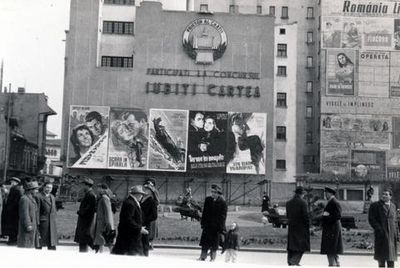
Calea Victoriei, balra a Strada Edgar Quinet, a szemben levő üres telek helyén ma a Calea Victoriei 32-34
1958 · FORTEPAN / Virány László · CC BY-SA 3.0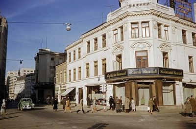
Strada Edgar Quinet - Calea Victoriei sarok, Casa Capșa étterem
1960 · FORTEPAN / UWM Libraries · CC BY-SA 3.0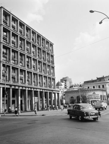
Calea Victoriei a Strada Edgar Quinet felől a Bulevardul Regina Elisabeta (Bulevardul Gheorghe Gheorghiu-Dej)
1965 · FORTEPAN / Bojár Sándor · CC BY-SA 3.0


On the old maps
The place appears on 45 maps and images, from 1790 to today:
- 1790 · Specht Plan
- 1791 · Ernst Plan
- 1846 · Borroczyn Plan
- 1852 · Borroczyn Plan
- 1864 · Szathmari Plan
- 1871 · Pappasoglu Plan
- 1883 · Cerkez Plan
- 1893 · Orăscu Plan
- 1896 · J. Don Plan
- 1900 · Plan of Bucharest 1900
- 1911 · Army Geographic Institute Plan
- 1914 · Socec Plan
- 1921 · Mihai Pantea Plan
- 1926 · Union Plan
- 1927 · Aerial photo 1927
- 1927 · Socec Plan
- 1928 · Industrial Plan
- 1931 · STB Plan
- 1931 · Unirea Plan
- 1934 · Wahing Plan
- 1938 · Aerial photo 1938
- 1938 · Teodorescu Plan
- 1939 · Simboteanu and Moldoveanu Plan
- ~1940 · Artillery Firing Plans
- 1943 · Aerial photo 1943
- 1962 · Cadastral Plan (center)
- 1966 · Satellite image 1966
- 1968 · Map of Bucharest 1968
- 1969 · Map of Bucharest 1969
- 1972 · Satellite image 1972
- 1974 · Cadastral Plan (center)
- 1976 · Satellite image 1976
- 1977 · Satellite image 1977
- 1978 · Satellite image 1978
- 1979 · Satellite image 1979
- 1980 · Satellite image 1980
- 1982 · Satellite image 1982
- 1982 · ITB Plan
- 1983 · Satellite image 1983
- 1984 · Satellite image 1984
- ~1985 · Soviet Topographic Map
- 1990 · Cadastral Plan
- 2001 · AGC Polonia Plan
- 2017 · Orthophoto 2017
- today · Current satellite
Nearby
- Sărindar Monastery · 70 m
- National Military Circle Palace · 90 m
- Telephone Palace · 90 m
- Doamnei Church · 130 m
- St. Nicholas Dintr-o Zi Church · 170 m
- Marmorosch Blank Bank Palace · 180 m