 Altădată
Historic building · 1911–1923
National Military Circle Palace
The National Military Circle Palace stands on the site of the old Sărindar Monastery, on marshy land that the Ministry of Domains had ceded as early as 1898; work began in 1911, and the main design was by Dimitrie Maimarolu, assisted by Victor Ștefănescu and Ernest Doneaud. The building, in the French Neoclassical style, was officially inaugurated in 1923, after its interiors had been ransacked during the German occupation in World War I. The eagles above the entrance are the work of the sculptor Ion Schmidt Faur. During the communist period it was called the Central House of the Army.
See the place on the old maps ›Text source: ro.wikipedia.org · summary based on the source
Old photographs
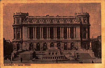
Cercul Militar
1900 · Institutul Național al Patrimoniului, colecția Andrei Ștomff · CC BY-SA 4.0
Circul Militar (Militärzirkus), vom Kaffee davor aus
1941 · Willy Pragher · CC BY 4.0
Sf. Gheorghe, Waage am Circul Militar (Militärzirkus)
1941 · Willy Pragher · CC BY 4.0
Verkehr vor dem Circul Militar (Militärzirkus), Fußgänger quer
1941 · Willy Pragher · CC BY 4.0
Verkehr vor dem Circul Militar (Militärzirkus), Fußgänger rechts
1941 · Willy Pragher · CC BY 4.0
Angriff vom 15. April 1944, verschüttete Straße, Edgar Quinet
1944 · Willy Pragher · CC BY 4.0


On the old maps
The place appears on 45 maps and images, from 1790 to today:
- 1790 · Specht Plan
- 1791 · Ernst Plan
- 1846 · Borroczyn Plan
- 1852 · Borroczyn Plan
- 1864 · Szathmari Plan
- 1871 · Pappasoglu Plan
- 1883 · Cerkez Plan
- 1893 · Orăscu Plan
- 1896 · J. Don Plan
- 1900 · Plan of Bucharest 1900
- 1911 · Army Geographic Institute Plan
- 1914 · Socec Plan
- 1921 · Mihai Pantea Plan
- 1926 · Union Plan
- 1927 · Aerial photo 1927
- 1927 · Socec Plan
- 1928 · Industrial Plan
- 1931 · STB Plan
- 1931 · Unirea Plan
- 1934 · Wahing Plan
- 1938 · Aerial photo 1938
- 1938 · Teodorescu Plan
- 1939 · Simboteanu and Moldoveanu Plan
- ~1940 · Artillery Firing Plans
- 1943 · Aerial photo 1943
- 1962 · Cadastral Plan (center)
- 1966 · Satellite image 1966
- 1968 · Map of Bucharest 1968
- 1969 · Map of Bucharest 1969
- 1972 · Satellite image 1972
- 1974 · Cadastral Plan (center)
- 1976 · Satellite image 1976
- 1977 · Satellite image 1977
- 1978 · Satellite image 1978
- 1979 · Satellite image 1979
- 1980 · Satellite image 1980
- 1982 · Satellite image 1982
- 1982 · ITB Plan
- 1983 · Satellite image 1983
- 1984 · Satellite image 1984
- ~1985 · Soviet Topographic Map
- 1990 · Cadastral Plan
- 2001 · AGC Polonia Plan
- 2017 · Orthophoto 2017
- today · Current satellite
Nearby
- Sărindar Monastery · 40 m
- Capșa House · 90 m
- Telephone Palace · 140 m
- Doamnei Church · 150 m
- Marmorosch Blank Bank Palace · 160 m
- Gheorghe Tattarescu Memorial Museum · 200 m