 Altădată
Monument or statue · 1921
Avântul Țării Monument
The “Avântul Țării” (“The Nation's Surge”) monument was erected in honor of the Romanian soldiers who fell in the 1913 campaign and is the work of the sculptor Emil Wilhelm Becker and the architect Arghir Culina. Inaugurated in 1921 on Calea Griviței, near several military units, it was later moved to Piața Valter Mărăcineanu, in front of the former Ministry of War, near Cișmigiu. On the travertine-clad pyramidal pedestal stand a woman holding a flag, a symbol of the Fatherland, and a soldier charging into attack, with a bronze eagle at the base. The bas-reliefs showing the troops crossing the Danube were destroyed during the communist period.
See the place on the old maps ›Text source: ro.wikipedia.org · summary based on the source
Old photographs
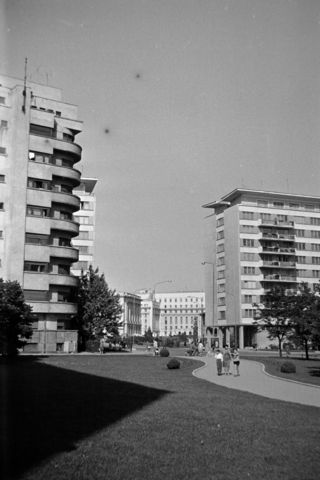
Piața Valter Mărăcineanu a Strada Ion Câmpineanu (13 Decembrie) felé nézve, középen a háttérben a Román Nemzet
1966 · FORTEPAN / Szűcs Lóránd · CC BY-SA 3.0
On the old maps
The place appears on 45 maps and images, from 1790 to today:
- 1790 · Specht Plan
- 1791 · Ernst Plan
- 1846 · Borroczyn Plan
- 1852 · Borroczyn Plan
- 1864 · Szathmari Plan
- 1871 · Pappasoglu Plan
- 1883 · Cerkez Plan
- 1893 · Orăscu Plan
- 1896 · J. Don Plan
- 1900 · Plan of Bucharest 1900
- 1911 · Army Geographic Institute Plan
- 1914 · Socec Plan
- 1921 · Mihai Pantea Plan
- 1926 · Union Plan
- 1927 · Aerial photo 1927
- 1927 · Socec Plan
- 1928 · Industrial Plan
- 1931 · STB Plan
- 1931 · Unirea Plan
- 1934 · Wahing Plan
- 1938 · Aerial photo 1938
- 1938 · Teodorescu Plan
- 1939 · Simboteanu and Moldoveanu Plan
- ~1940 · Artillery Firing Plans
- 1943 · Aerial photo 1943
- 1962 · Cadastral Plan (center)
- 1966 · Satellite image 1966
- 1968 · Map of Bucharest 1968
- 1969 · Map of Bucharest 1969
- 1972 · Satellite image 1972
- 1974 · Cadastral Plan (center)
- 1976 · Satellite image 1976
- 1977 · Satellite image 1977
- 1978 · Satellite image 1978
- 1979 · Satellite image 1979
- 1980 · Satellite image 1980
- 1982 · Satellite image 1982
- 1982 · ITB Plan
- 1983 · Satellite image 1983
- 1984 · Satellite image 1984
- ~1985 · Soviet Topographic Map
- 1990 · Cadastral Plan
- 2001 · AGC Polonia Plan
- 2017 · Orthophoto 2017
- today · Current satellite
Nearby
- Brezoianu Church (lost) · 120 m
- Stejarul Church · 180 m
- St. Ionică Church (lost) · 200 m
- Palace Hall · 220 m
- Sissi Stefanidi Spring · 270 m
- Reformed (Calvinist) Church · 270 m