 Altădată
Existing church · 1915–1916
Italian Church
The Italian Church (Most Holy Redeemer), on Nicolae Bălcescu Boulevard, was built in 1915–1916 by the Italian community of Bucharest, with the support of the Italian ambassador, Baron Carlo Fasciotti. The plans, by Mario Stoppa and Giuseppe Tiraboschi, follow the model of northern Italian churches: it has Romanesque features, a few Gothic and Art Deco elements, a brick exterior and a tower with three bells. Archbishop Raymund Netzhammer consecrated it on 2 July 1916; among the priests who served here was Blessed Anton Durcovici.
See the place on the old maps ›Text source: ro.wikipedia.org · summary based on the source
Old photographs

Boulevard Bratianu, von oben, Gesamtansicht
1937 · Willy Pragher · CC BY 4.0
Boulevard Bratianu, gegenüberliegender Blick auf italienische Kirche
1941 · Willy Pragher · CC BY 4.0
Bulevardul Nicolae Bălcescu
1945 · Public domain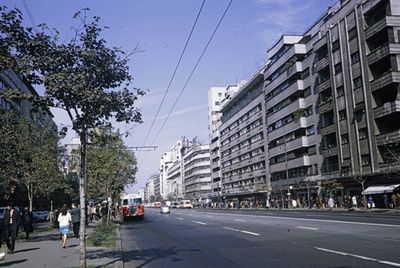
a Bulevardul Nicolae Bălcescu a Biserica Italiană-tól a Strada C
1970 · FORTEPAN / UWM Libraries · CC BY-SA 3.0
Revolutia Bucuresti
1989 · Attribution


On the old maps
The place appears on 44 maps and images, from 1790 to today:
- 1790 · Specht Plan
- 1791 · Ernst Plan
- 1846 · Borroczyn Plan
- 1852 · Borroczyn Plan
- 1864 · Szathmari Plan
- 1871 · Pappasoglu Plan
- 1883 · Cerkez Plan
- 1893 · Orăscu Plan
- 1896 · J. Don Plan
- 1900 · Plan of Bucharest 1900
- 1911 · Army Geographic Institute Plan
- 1914 · Socec Plan
- 1921 · Mihai Pantea Plan
- 1926 · Union Plan
- 1927 · Aerial photo 1927
- 1927 · Socec Plan
- 1928 · Industrial Plan
- 1931 · STB Plan
- 1931 · Unirea Plan
- 1934 · Wahing Plan
- 1938 · Aerial photo 1938
- 1938 · Teodorescu Plan
- 1939 · Simboteanu and Moldoveanu Plan
- ~1940 · Artillery Firing Plans
- 1943 · Aerial photo 1943
- 1966 · Satellite image 1966
- 1968 · Map of Bucharest 1968
- 1969 · Map of Bucharest 1969
- 1972 · Satellite image 1972
- 1974 · Cadastral Plan (center)
- 1976 · Satellite image 1976
- 1977 · Satellite image 1977
- 1978 · Satellite image 1978
- 1979 · Satellite image 1979
- 1980 · Satellite image 1980
- 1982 · Satellite image 1982
- 1982 · ITB Plan
- 1983 · Satellite image 1983
- 1984 · Satellite image 1984
- ~1985 · Soviet Topographic Map
- 1990 · Cadastral Plan
- 2001 · AGC Polonia Plan
- 2017 · Orthophoto 2017
- today · Current satellite
Nearby
- Boteanu Church · 150 m
- Ciclop Garage · 210 m
- Theodor Aman Museum · 210 m
- Enei Church · 320 m
- Batiștei Church · 320 m
- Romanian Athenaeum · 320 m