 Altădată
Existing church · sec. al XVI-lea (atestată 1563)
St. Anthony Church – Curtea Veche
The Curtea Veche (Old Court) Church, dedicated to the Annunciation and St. Anthony the Great, is considered the oldest church in Bucharest and the only one left of the four that belonged to the former Princely Court. The 1715 inscription names Mircea Ciobanul, buried here in 1559, as its founder, and the first document mentioning it dates from 1563. In the Great Fire of 1847 the chapel of the nearby prison, dedicated to St. Anthony, also burned; never rebuilt, it passed its dedication on to the Old Court Church. The 1928–1935 restoration revealed the decorative 16th-century brickwork.
See the place on the old maps ›Text source: en.wikipedia.org · summary based on the source
Old photographs
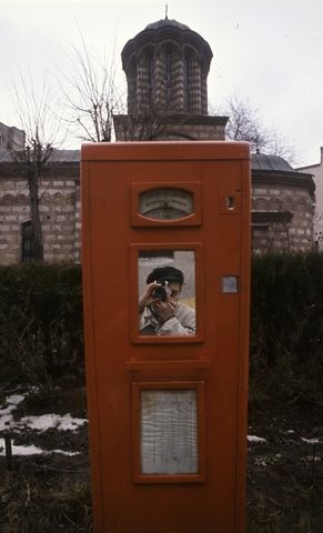
Strada Franceza, Szent Antal-templom (Biserica Sfantul Anton)
1986 · FORTEPAN / Urbán Tamás · CC BY-SA 3.0
On the old maps
The place appears on 44 maps and images, from 1790 to today:
- 1790 · Specht Plan
- 1791 · Ernst Plan
- 1846 · Borroczyn Plan
- 1852 · Borroczyn Plan
- 1864 · Szathmari Plan
- 1871 · Pappasoglu Plan
- 1883 · Cerkez Plan
- 1893 · Orăscu Plan
- 1896 · J. Don Plan
- 1900 · Plan of Bucharest 1900
- 1911 · Army Geographic Institute Plan
- 1914 · Socec Plan
- 1921 · Mihai Pantea Plan
- 1926 · Union Plan
- 1927 · Aerial photo 1927
- 1927 · Socec Plan
- 1928 · Industrial Plan
- 1931 · STB Plan
- 1931 · Unirea Plan
- 1934 · Wahing Plan
- 1938 · Aerial photo 1938
- 1938 · Teodorescu Plan
- 1939 · Simboteanu and Moldoveanu Plan
- ~1940 · Artillery Firing Plans
- 1943 · Aerial photo 1943
- 1962 · Cadastral Plan (center)
- 1966 · Satellite image 1966
- 1968 · Map of Bucharest 1968
- 1969 · Map of Bucharest 1969
- 1972 · Satellite image 1972
- 1974 · Cadastral Plan (center)
- 1976 · Satellite image 1976
- 1977 · Satellite image 1977
- 1978 · Satellite image 1978
- 1979 · Satellite image 1979
- 1980 · Satellite image 1980
- 1982 · Satellite image 1982
- 1982 · ITB Plan
- 1983 · Satellite image 1983
- 1984 · Satellite image 1984
- ~1985 · Soviet Topographic Map
- 2001 · AGC Polonia Plan
- 2017 · Orthophoto 2017
- today · Current satellite
Nearby
- Old Coffeehouse · 60 m
- Manuc's Inn · 70 m
- Curtea Veche Museum · 80 m
- St. John New Church (St. John – Piață) · 170 m
- St. John the Baptist Church (St. John New) · 200 m
- She-Wolf Statue · 200 m