 Altădată
Historic building · 1806–1808
Manuc's Inn
Manuc's Inn was built between 1806 and 1808 by Manuc Bei (Manuc Mârzaian), born in Rusciuc (today Ruse) and later a dragoman of the Sublime Porte, on land that had belonged to the Princely Court. Probably the largest inn in the city, it had 15 vaulted cellars, 23 shops on the ground floor and more than a hundred rooms upstairs. It was here that the negotiations ending the Russo-Turkish War took place and that the 1812 Treaty of Bucharest was signed, by which Russia occupied the territory between the Prut and the Dniester. Restored several times, most recently in 1991–1992, it has largely kept its former appearance.
See the place on the old maps ›Text source: ro.wikipedia.org · summary based on the source
Old photographs
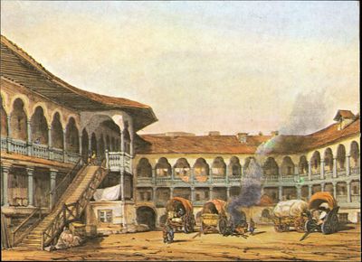
Hanul lui Manuc din București
1800 · Institutul Național al Patrimoniului, colecția Andrei Ștomff · CC BY-SA 4.0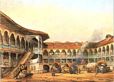
Hanul lui Manuc din București
1800 · Institutul Național al Patrimoniului, colecția Andrei Ștomff · CC BY-SA 4.0
Hanul Manuk, Hof
1971 · Willy Pragher · CC BY 4.0

On the old maps
The place appears on 45 maps and images, from 1790 to today:
- 1790 · Specht Plan
- 1791 · Ernst Plan
- 1846 · Borroczyn Plan
- 1852 · Borroczyn Plan
- 1864 · Szathmari Plan
- 1871 · Pappasoglu Plan
- 1883 · Cerkez Plan
- 1893 · Orăscu Plan
- 1896 · J. Don Plan
- 1900 · Plan of Bucharest 1900
- 1911 · Army Geographic Institute Plan
- 1914 · Socec Plan
- 1921 · Mihai Pantea Plan
- 1926 · Union Plan
- 1927 · Aerial photo 1927
- 1927 · Socec Plan
- 1928 · Industrial Plan
- 1931 · STB Plan
- 1931 · Unirea Plan
- 1934 · Wahing Plan
- 1938 · Aerial photo 1938
- 1938 · Teodorescu Plan
- 1939 · Simboteanu and Moldoveanu Plan
- ~1940 · Artillery Firing Plans
- 1943 · Aerial photo 1943
- 1962 · Cadastral Plan (center)
- 1966 · Satellite image 1966
- 1968 · Map of Bucharest 1968
- 1969 · Map of Bucharest 1969
- 1972 · Satellite image 1972
- 1974 · Cadastral Plan (center)
- 1976 · Satellite image 1976
- 1977 · Satellite image 1977
- 1978 · Satellite image 1978
- 1979 · Satellite image 1979
- 1980 · Satellite image 1980
- 1982 · Satellite image 1982
- 1982 · ITB Plan
- 1983 · Satellite image 1983
- 1984 · Satellite image 1984
- ~1985 · Soviet Topographic Map
- 1990 · Cadastral Plan
- 2001 · AGC Polonia Plan
- 2017 · Orthophoto 2017
- today · Current satellite
Nearby
- St. Anthony Church – Curtea Veche · 70 m
- Curtea Veche Museum · 100 m
- Old Coffeehouse · 100 m
- St. John New Church (St. John – Piață) · 140 m
- St. John the Baptist Church (St. John New) · 170 m
- Funerary Monument of Domnița Bălașa · 210 m