 Altădată
Monument or statue · 1884
Funerary Monument of Domnița Bălașa
The funerary monument of Domnița Bălașa, titled “Sorrow”, was carved in marble in 1884 by Ion Georgescu (1856–1898) and adorns the princess's tomb in the church that bears her name, on Sfinții Apostoli Street. The princess (1693–1752) was the sixth of Constantin Brâncoveanu's daughters. The tomb is inside the church, between the pronaos and the naos, on the right side. The work is included in the List of Historic Monuments.
See the place on the old maps ›Text source: ro.wikipedia.org · summary based on the source
Old photographs
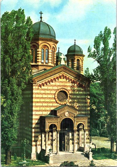
Biserica Domnița Bălașa, sec. XIX
1800 · Institutul Național al Patrimoniului, colecția Andrei Ștomff · CC BY-SA 4.0
L'Eglise Domnitza Balacha
1902 · Alexandru Antoniu · Public domain
La Statue de la Princesse Balascha
1902 · Alexandru Antoniu · Public domain
Biserica Domniţa Bălaşa din Bucureşti
1910 · Leopold Adler · Public domain


On the old maps
The place appears on 45 maps and images, from 1790 to today:
- 1790 · Specht Plan
- 1791 · Ernst Plan
- 1846 · Borroczyn Plan
- 1852 · Borroczyn Plan
- 1864 · Szathmari Plan
- 1871 · Pappasoglu Plan
- 1883 · Cerkez Plan
- 1893 · Orăscu Plan
- 1896 · J. Don Plan
- 1900 · Plan of Bucharest 1900
- 1911 · Army Geographic Institute Plan
- 1914 · Socec Plan
- 1921 · Mihai Pantea Plan
- 1926 · Union Plan
- 1927 · Aerial photo 1927
- 1927 · Socec Plan
- 1928 · Industrial Plan
- 1931 · STB Plan
- 1931 · Unirea Plan
- 1934 · Wahing Plan
- 1938 · Aerial photo 1938
- 1938 · Teodorescu Plan
- 1939 · Simboteanu and Moldoveanu Plan
- ~1940 · Artillery Firing Plans
- 1943 · Aerial photo 1943
- 1962 · Cadastral Plan (center)
- 1966 · Satellite image 1966
- 1968 · Map of Bucharest 1968
- 1969 · Map of Bucharest 1969
- 1972 · Satellite image 1972
- 1974 · Cadastral Plan (center)
- 1976 · Satellite image 1976
- 1977 · Satellite image 1977
- 1978 · Satellite image 1978
- 1979 · Satellite image 1979
- 1980 · Satellite image 1980
- 1982 · Satellite image 1982
- 1982 · ITB Plan
- 1983 · Satellite image 1983
- 1984 · Satellite image 1984
- ~1985 · Soviet Topographic Map
- 1990 · Cadastral Plan
- 2001 · AGC Polonia Plan
- 2017 · Orthophoto 2017
- today · Current satellite
Nearby
- Domnița Bălașa Church · 0 m
- St. Nicholas Church (lost) · 100 m
- Curtea Veche Museum · 190 m
- Manuc's Inn · 210 m
- St. Anthony Church – Curtea Veche · 250 m
- St. Elijah Church – Rahova · 270 m